A satellite launched in 2022 is providing images and unparalleled data about an ephemeral lake.
The NASA-backed initiative highlights a partnership between the United States and France that can "fill the data gap" with the Surface Water and Ocean Topography satellite, Phys.org reported.
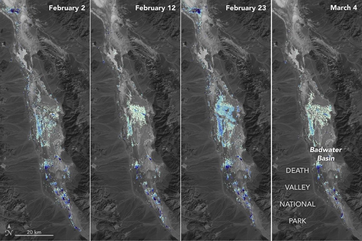
In August, when record rain began falling in California to reverse a yearslong drought, a temporary lake, known as Lake Manly, reemerged in Death Valley. SWOT has been photographing the area and measuring water depths.
In the ice age, Badwater Basin featured a 700-foot-deep lake, which has been extinct for 10,000 years and is now salt flats. It is the lowest point in North America at 282 feet below sea level.
"This is a really cool example of how SWOT can track how unique lake systems work," said Tamlin Pavelsky, NASA freshwater science lead for SWOT.
Lake Manly, which has reappeared before, expanded to about six miles long and three miles wide after more record rain in February. Over weeks of measurement, its depth ranged from less than 1.5 feet to about three feet, according to researchers who used water level data from SWOT and land elevation information from the U.S. Geological Survey, per Phys.org.
SWOT's greatest strength, however, may be in the maps it is building of Earth's waters. Thanks to the Ka-band Radar Interferometer — a boom with two antennas separated by 33 feet — the satellite sends radar pulses toward surface water, "developing one of the most detailed and comprehensive views of the planet's oceans and freshwater lakes and rivers."
This is especially important as rising temperatures and water rights issues create problems for lakes all over the world, including some in the vicinity of Death Valley. The concern is that, despite temporary relief, these critical resources may never recover if they dry up. On the other hand, wet climates may only get more rainfall.
"Strong winds are enough to move the freshwater body a couple of miles, as happened from Feb. 29 to March 2," Phys.org reported. "Since there isn't typically water in Badwater Basin, researchers don't have permanent instruments in place for studying water in this area. SWOT can fill the data gap for when places like this, and others around the world, become inundated."
Phys.org noted that the data is also being used to help scientists and engineers understand how the satellite works.
"We've never flown a Ka-band radar like the KaRIn instrument on a satellite before," Pavelsky said.

Join our free newsletter for cool news and cool tips that make it easy to help yourself while helping the planet.